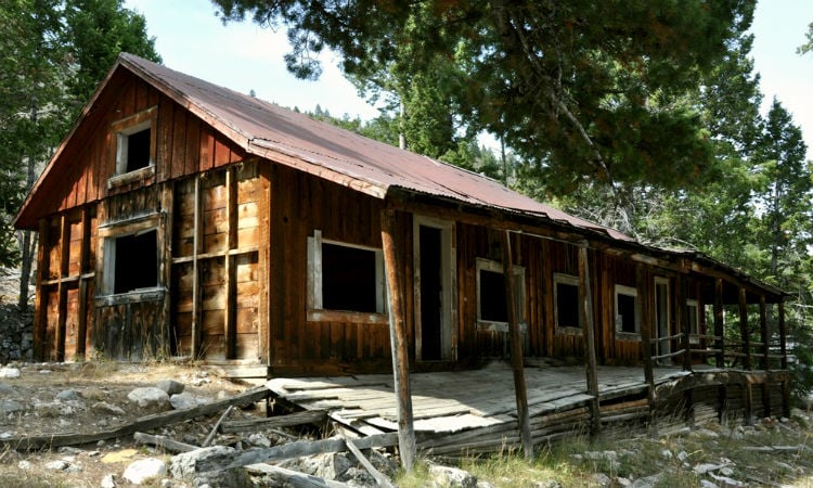
The Ross home on Mansion Row in Upper Gilmore.
If you travel 65 miles south of Salmon, ID. via Hwy 28 you will pass the once booming mining town of Gilmore. In its hay day, the town supported a population of 600, plus hotels, a mercantile, bank, post office, and a series of local business. Numerous residences included several mansions in Upper Gilmore. There was also a city park and a large school that enrolled 71 students in 1928.
Additionally, to move ore and supplies economically meant the building of The Gilmore and Pittsburgh Railroad in 1910. In fact, it was built in just one year with hand labor. The railroad carried the ore from Gilmore across the Continental Divide to Armstead, MT.
Like most mining communities, the boom (1910 through the 1920s) didn’t last long. So, it was over in 1929. The demise of Gilmore began when the main power plant (that supplied power to the mines) exploded. With loss of the plant, with the the Great Depression, engineering challenges, and increasing cost of reaching the remaining ore, signaled the end of mining. Most of the population left town within a few months of the explosion. Gilmore was largely a ghost town by the end of the 1930’s. When all was said and done, the mines produced nearly $486 million dollars (present day worth) of silver with a trace amount of gold.
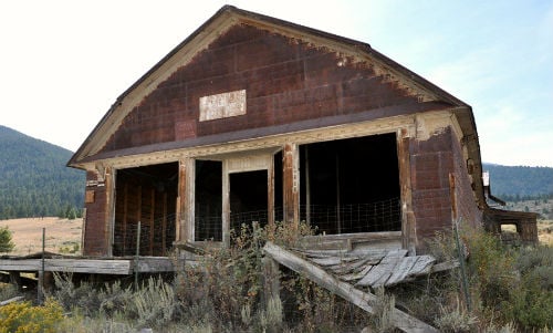
The General Store that once served a population of 600.
Explore Present Day Gilmore
Recently, the Bureau of Land Management (BLM) partnered with historic preservationists from the National Park Service and the Idaho State Historic Preservation Office. As a result, the plan was to preserve the area so future generations would be able to learn about this piece of Idaho’s history. As part of this effort, there are interpretive panels by the old Gilmore general store.
Currently, most of the site contains many original buildings to view and is on private property. The original town (Upper Gilmore) is located high on the hill near the mines. This is open for the more adventurous to explore.
RVing the road less traveled and hobnobbing with ghosts of yesteryear, just another adventure in RVing!
When You Travel Here:
You will find the interpretive panels mentioned above at: N44° 27.461’ W113° 16.193’
To visit Upper Gilmore head up the hill and turn right at: N44° 27.368’ W113° 17.190’
Camping:
Meadow Lake Campground (the only campground for miles) is on a beautiful alpine lake. It’s about 4 miles above Gilmore at N44° 26.100’ W113°19.043’ via a gravel road. There are several campgrounds available in Salmon, if you wish to enjoy day trips to the area.
Boondockers will find a couple of choice campsites just off the main road. They are among some ghostly structures by turning left at 44°27.410’ W113°16.646’ on the outskirts of town.
If you are just passing through the area and won’t be camping, there is a large pull-off along the highway at N 44° 27.400’ W113° 14.473’ where you can drop your RV and continue to the town site with your tow vehicle or dinghy.

Drove by there last week on Highway 28. Another interesting part of Idaho with an interesting history. Now I have to go back with my sxs in tow and explore the roads less traveled. Does anyone have any road-trail information for atv-sxs travel in the area of Gilmore, Tendoy, Lemhi and Leador. Thanks
I give (Gilmore Day History Tours) of the 3 Towns, & the over 68 Mines in the Gilmore area every Summer. Just bring your A.T.V.’s & join me this Summer in Gilmore. You can Message me on My Gilmore Web Site (A Place Called Gilmore Idaho) on Facebook, & we will make your Gilmore History Day Tour happen. – Dan L.
Be Aware as you visit the Gilmore area, that it is all Private, as is the upper Mines & all of the Old Town area above Gilmore, has all been sold off to new Owners. I know where the B.L.M. Public Lands are in the area, & the Private Lands, so you don’t get into a Private Property dispute. I maintain the Gilmore Cemetery up above Gilmore, as well as my Airplane Crash site area the next canyon to the South of Gilmore. I include these on my Gilmore Day History Tours. – Dan L.
Does the ghost town of Gilmore have anything to do with the old Gilmore Ranch established on Johns Creek/Gilmore Creek near Buffalo Hump, about 30 miles out of Grangeville?