If you’ve traveled by RV in the last decade, you know that RV rest areas are disappearing. These permanently shuttered pit stops dot America’s highway system. But a few of these concrete sentinels continue standing tall as symbols of another time in America. A new photo book called “The Last Stop” shares their stories and preserves their legacy before they disappear altogether.
Offbeat RV Rest Areas Explained in “The Last Stop”

The Last Stop is a must-have for road trip aficionados. Photo by Ryann Ford.
As RVers we have all the conveniences of home when we roam. But even the most hard-driving need an occasional pause from the blacktop at rest areas and welcome centers. Oftentimes when we find ourselves a hundred miles in the middle of nowhere and in desperate need of a break, a highway rest stop suddenly appears on the horizon. When architecture at resting places can be seen from a mile away, pulling over for a few minutes isn’t a hassle. It’s irresistible.
If you’ve ever noticed the covered wagon picnic shelters near White Sands National Monument, or the Texas picnic shelters along I-10 that resemble giant covered wagons, you’ll love this stunning new photo book.
“The Last Stop: Vanishing Rest Stops of the American Roadside” is the culmination of a seven-year project by California photographer Ryann Ford. Each page spotlights the most unforgettable RV rest areas of the American West built during the 1950s and ’60s.
From oil well structures built on the roofs of rest area bathrooms to picnic shelters shaded by giant metal teepees, its easy to pull over and stay a while at these funky RV rest areas. As we look around, we can get acquainted with the biggest symbols. That’s when we find ourselves wondering: did rest area architects have a bigger purpose in mind besides bathroom breaks? Apparently, they did.
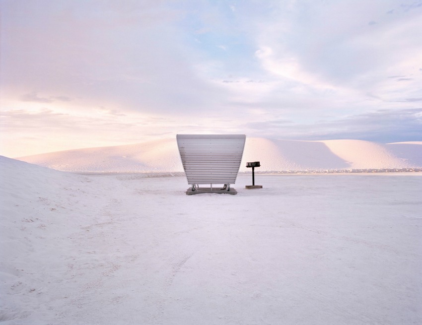
White Sands National Monument rest area picnic shelters. Image: Ryann Ford.
The Story Behind Those Funky RV Rest Areas
“Regionalism is one of the most distinct and historically significant embodiments of the rest area program. It reached its pinnacle in the late 1960s and can be seen most powerfully in the Midwestern and Southwestern states. This design movement was a kind of regional branding that sought to define “local.”
In the West, regional design met the grandeur of the landscape. It acted as a powerful tool for communicating a sense of place.” – A Brief History of Rest Stops, by Joanna M. Dowling in “The Last Stop.”
The Last Stop is much more than a coffee table book with gorgeous photos. It’s so notable that the September 2016 issue of Oprah Magazine gave Ford’s work a thumbs up. The publication says the book “just might make you nostalgic for family road trips.” Through stunning photography and fascinating narrative, The Last Stop tells why so many RV rest areas look the way they do and why they’re disappearing before our eyes.
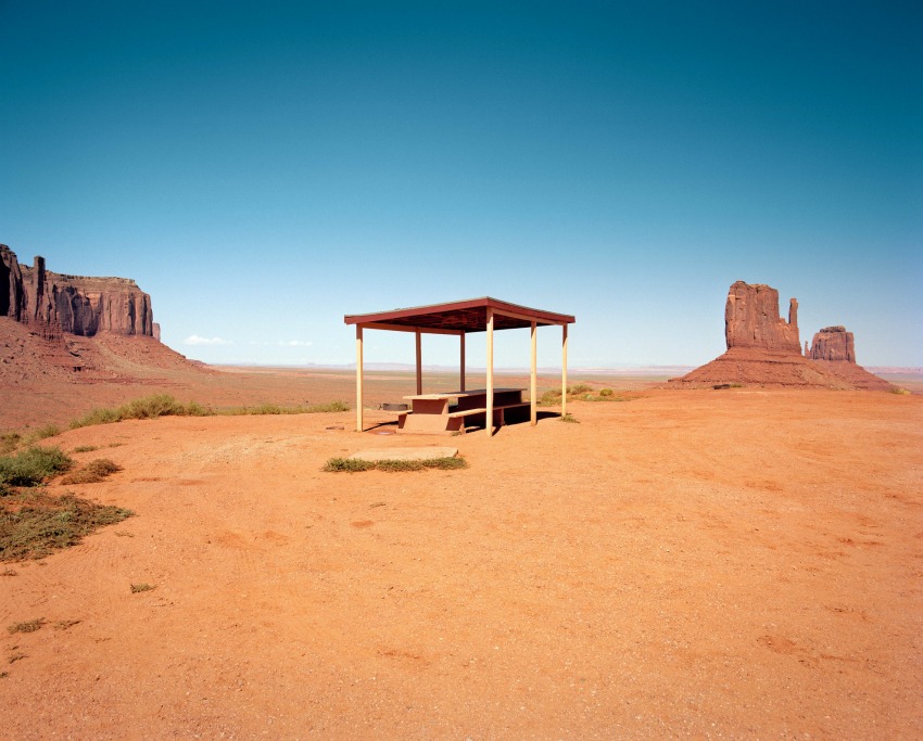
Pit stop in Monument Valley, Arizona. Photo by Ryann Ford.
Every day more mundane gas stations and look-alike fast food restaurants appear along the highways. Every year, more of these old iconic rest stops will disappear. It won’t be long before they go the way of legendary Route 66 or other icons of mid-20th century American road trips.
The review copy Ford sent to RV Life made one thing clear: Learn why this small slice of road trip history matters, before it’s too late to enjoy these pit stops on your next adventure.
Pick up a copy of “The Last Stop” for yourself on Amazon.

My wife and I have travelled around the Canada & the USA quite a lot in the past 10 years now 2017, what we have noticed is a lot of the rest areas are being closed down due to a lack of Maintenance, or people who do not look after what is still there, they destroy the wonderful places to pull in for a rest or stop for a picnic lunch. Maybe it is because were from the old school of thought and enjoy these places more than the people today do.
Stude
Stude, I agree with your observations. To state in the positive: cleaning up after someone else is useful to
keep places open. Local advocates can also organize a ‘Friends Of…” with local agencies. With increased homelessness and not everyone is lucky enough to have a rig of any sort. Increased pressure by the banking/real estate corporations to create rents that consume most of a families resources making citizens more vulnerable to ‘bad luck’ it’s imperative that campgrounds be kept open, rest stops be kept open for in-transit safety. I typically clean messes up (with gloves). Seems if some unaware people find a spot already trashed they will only add to the mayhem. Those of us who notice may have to remember that
20% of the people get 80% of the work done. Thanks for your post.
whenever the government is involved, you can count on things taking 5 x as long and 3x as much as they should. The restroom area on NB280 in San Mateo County took about 2 years, it was bizarre.
My wife & I have been RVing for about 10 years now, We enjoy traveling all over Pacific Coast to the Atlantic Cost.. Much of the time when we need a rest and take the next exit we find piles of trash even when there are trash can provided by the state. People walk there dogs or even turn them loose and never clean up after them. It’s a shame that there isn’t some way to catch these people and slap a HUGE fine on them and after a while people my think twice. If I see people dumping their trash I get the License plate number and call 911. But then I am told that unless you can Identify the people the license plate is worthless. Kind of a NO win situation
We travel I5 area quite a lot when going down to Portland, OR , the rest stops along this route are in real good condition, kept clean, no garbage in the stop, some you can get a coffee which is nice for a Quick break. We travelled to Northern BC, Yukon right up to Dawson City then take Ferry across the Yukon River then drive the Top of the World Hwy. stopping at Poker Creek (USA Border) population 3 got out passports stamped, then we got 11 miles of real nice new blacktop, once the 11 miles were gone we were back on gravel road, spent the night in Chicken City, stopped in at the Gift Shops, Liquor Store and the Pie shop for piece of pie and coffee. From there headed for Tok pronounced (Toke) got some groceries then proceeded to nice spot beside the river and had dinner went to start MH and nothing no power at all, Peterbuilt through Good Sam sent their man down to us and he jumped our starter to get us going until we reached their shop 100 miles up the road.
We spent 2 days waiting for parts etc. but were on the road pretty quick. We did some travelling in and around Fairbanks until we were back on the road.
Got to Denali found a place to camp for a few days, we did a Dog training show you get to hold all these new puppies that they want to know and like people then we did a 45 minute talk and show on how the Iditarod race works and how they do it, usually pacing around 134th but one of these days they will win. We never got to see Denali while there as fog ran all around and down to where there was nothing to see. Rained most of the time there or really overcast.
Next stop Anchorage AK spent a good week here then travelled to Whittier AK, Seward ak, from here we headed for Valdez, AK and spent around 4 days here, moose, BIG Brown Bears or what we in the lower area of BC Call Grizzly Bears. From Valdez we headed up to Tok and down the AK hwy to Haines , AK and to get there you travel through parts of Alaska then hit the border of Ak, Yukon then BC then AK again and so on. Haines was good we got a private ferry here to takes us to Juneau for the day was a good day there and on the Ferry Ride, saw whales, seals trying to escape the killer whales while they slept on a bell boy. You can still see Glaciers but most are Hanging Glaciers now.
From Haines we travelled back to Whitehorse, YK to stock up on Groceries for our trip home but first we headed for Atlin, BC so I could show my wife where I was when there in the mid 70’s to me was a long time ago. We camped in the native run campsite with no dump station so make you dump before going here. Atlin Lake is way big and I mean way big. This is not a lake one should travel in a 12′ boat with a 6hp merc. because if the wind picks up and your out there then your in trouble. Lake water is real cold, best to have a wet/cold water suit on when out there fishing.
We were lucky we missed the Music Festival of 3000 screaming drunk kids, they were all leaving when we arrived. I got to look around a bit more when there and see things I did not get to see when there before. We left there for Hwy 37 which is the Stewart, Cassiar Hwy. We stopped at Jade City and checked it out also spent night there in the parking lot, then in AM headed for Stewart & Hyder, AK and the Salmon Glacier. No bears yet as fish not coming up the rivers. We did all of this area for 3 days then headed down to Pr. Rupert which was another hang out in the 70’s as I did some time working for the CNR, lots of Changes for it in that area now as they are based back of the Ferry area.
We spent 2 days here, 1 day doing a tour at Port Edward Canary.
We left here for a leisurely trip home, stopping in at the Vulture Garage at Spences Bridge for the night, then headed for home the next day. Now the cleaning of the MH had to go to Bellingham to get a decent was for cheap dollars then a friend waxed the whole MH, My wife and I did some more cleaning of the storage door areas etc. now she is up for sale and if your interested in a real nice WInnebago 2006 Sunova Special Edition 29’8″ or well say 30′ Check out the listing on Craigslist it is all there with pictures.
We have down sized to a smaller unit built for two.
stude