If you have been following this blog over the past several years, you know I am a big fan of using Google Earth to locate boondocking campsites in advance. Ninety nine percent of the time the information I have gleaned in advance from Google Earth is what I find upon arriving at a chosen site. However, there is that one time out of a hundred when things are not as expected. Let me share one of my recent misadventures with Google Earth.
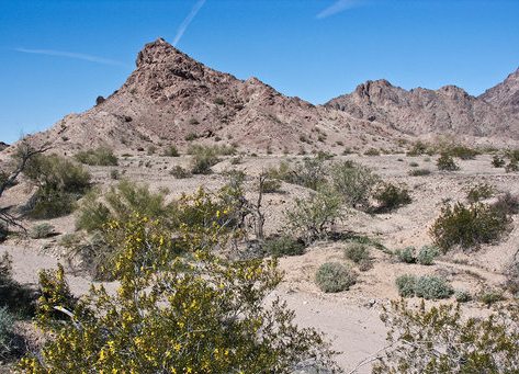
 Needing to locate a place to boondock between Tucson, AZ and Salton City, CA last fall, I went to Google Earth to see what options were available in the desert east of Yuma. After a little searching, I found a nice spot to the east of the Mohawk Mountains just off of I-8. It showed what appeared to be a well graded dirt road departing the freeway interchange leading into the desert. Street view showed the area vegetated with mesquite trees and a great view of the rugged Mohawk Mountains. I recorded the coordinates that would lead us to our desert oasis.
Upon exiting the freeway days later I found the dirt road was well graded, but not well traveled. It seems a large volume of water had rushed down the dry wash in recent history taking the section of road that crossed the dry wash with it. The washout was either not discernible on Google Earth or occurred since the last photos were posted. Disappointed to be cut off from our selected desert oasis, we moved on down the road to a backup site. Yes, we could have stayed between the freeway and the end of the road at the dry wash, but if I had wanted to deal with the freeway noise, I would have just stayed in one of the many RV parks along the freeway in Yuma! For me boondocking is all about the solitude.
Arriving to the unexpected, just another adventure in RVing!

Nice blog, Dave.
Testing
Testing
Just had a chance to read this one Dave. All I can say is that you’re a lot braver than I am! I’ve had too many disappointments with Google Earth so I don’t rely on it anymore, but instead use the Escapees Days End Directory (which reminds me, I should write about that!). Would love to hear more about how you scout out a location once you arrive: do you head out in a toad or just go for it?
Rene,
While my wife and I aren’t full time RVers (yet), we do take an extended 7-8 week excursion to the SW each fall. We primarily boondock, moving every few days to explore a new area. Typically I have all the boondocking sites selected ,mainly via Google Earth before we ever leave home (we never drop the trailer and scout for them on the ground once we arrive in an area, too time consuming). As noted in my blog 99% of the time the campsite is as “advertised” on Google Earth. You need to sit in on one of my boondocking seminars. In the meantime check out a series of blogs I wrote on the subject at: http://www.rvboondockingnews.com/2012/03/how-do-you-find-boondocking-spot.html and older RV Life posts.