A reoccurring question during my boondocking seminars and responses to some of my blog posts is, “Do you physically survey (walk/drive) road conditions leading to a boondocking site before heading in with your RV?”
I typically reply that I am so comfortable with what I have researched in advance concerning road conditions that I rarely walk or drive the road (without the RV in tow) before proceeding with my travel trailer.
In this and the next several posts, I will be sharing the items I look for online before ever leaving the asphalt and heading down a “less improved” road to a boondock site.

User-posted photo showing road conditions – Photo via Google Earth
In this entry, we will share what to look for using the satellite view on Google Earth.
I start by locating a boondocking site near the location/activity I want to enjoy. These sites show up where the natural vegetation has been disturbed (on public land) from years of vehicle use/parking and most often you will also be able to discern a fire ring made of rocks.
From the boondocking site, I work back towards the asphalt where I will be turning off the main road. Things I look for along the route are:
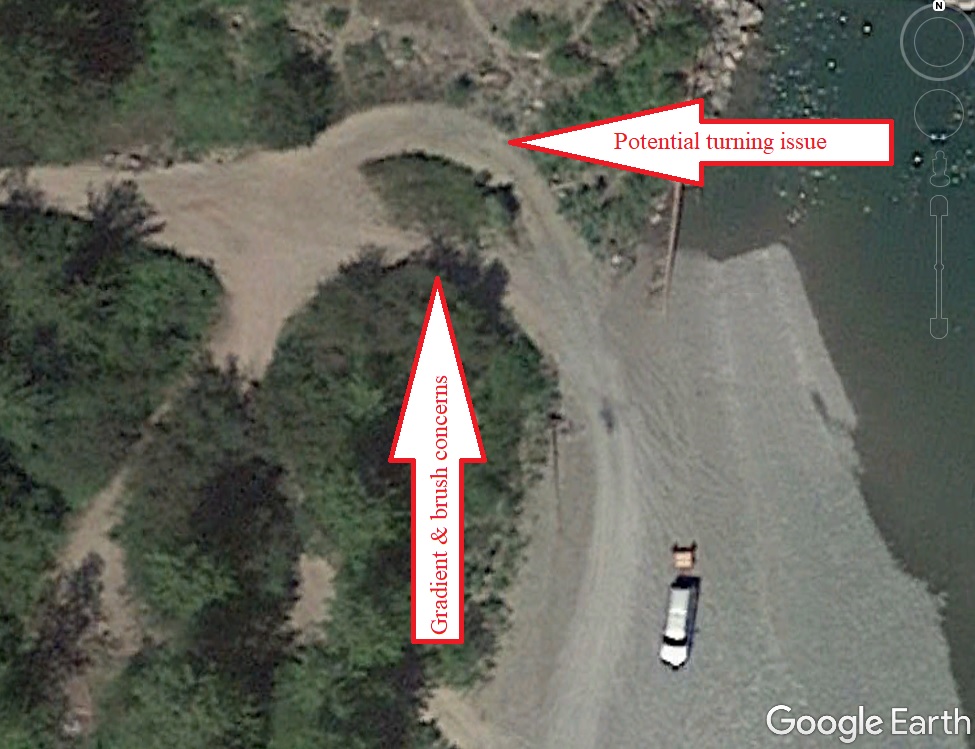
- Sharp curves in the road that would be difficult to navigate.
- Gradient—I run the cursor along the road to watch the elevation listed at the bottom of the screen to determine what the gradient of the road is and if there are any major dips or humps that might challenge the clearance of my truck or travel trailer.
- The distance I will have to travel to get to the boondocking site from the main road using either the “Ruler” found in Tools or the scale located in the bottom left corner.
- The width of the road using the scale as noted above.
- How well the road is maintained or maybe isn’t maintained. Signs that it is maintained include lack of grass and/or weeds growing down the center of the road tell me it is most likely graded on a regular basis and well-traveled. Uniform shoulders and width also serve as indicators that the road is graded regularly.
- What are the options for turning around along the route (if needed)?
- Drainages/creek crossings/washouts/swales.
- Initial access—I look at the turnoff from the asphalt to see if there might be a gate that will be indicated by a line across the road with a parallel shadow, which tells me the line is elevated above the road (as it is casting a shadow). Note: If on public land, it may only be a cattle gate keeping livestock on leased grazing lands often found in the West. The universal rule concerning gates is leave the gate as you found it (or leave all gates as found) is an important rule of courtesy in rural areas throughout the world. If a gate is found open, it should be left open, and if it is closed, it should be left closed (after passing through).
- Is there brush encroaching the road or are there trees overhanging the road that might damage my RV?
- Does the road start out as surfaced (chip sealed or paved) and then turn to dirt/gravel farther along the route?
- Are there any user-posted pictures, indicated by blue circles, along the back road I plan to travel that depict the actual road?
Gradient & turns – Photo via Google Earth
As you can see, a little advance research can provide a wealth of information concerning road conditions to a boondocking site long before you ever arrive to navigate the road in your RV.
Please note that I have been towing trailers before I was old enough to obtain a driver’s license and I have more ground clearance than most RVs, so I might be more confident than other RVers. If you are in doubt about access road conditions I encourage you to survey the road before proceeding with your RV.
In the next installment, we will look at using Google Earth street view to provide us clues to access road conditions. Traveling a back road to a boondocking site with confidence, just another adventure in RVing!

Always a good idea to check the date on the bottom to see when that photo of the area was taken some are years out of date,, and roads could be washed out or overgrown
Seann,
Thanks for sharing as I forgot to include that – always mention it during my seminars
Great information. We have been full timing for almost 5 years and though we bought a fully self contained diesel pusher motorhome, we have not boondocked yet. Mostly because I did not have the knowledge on my electrical systems to give me confidence to do so. We did dry camp in a state park in Alaska in 2018 for about two days and had a scare when the coach would not start/turn over the morning we were to leave. We shut all of the electrical items down and went for a walk with our dogs to let the batteries self regenerate, as they will do when still relatively new, and then we were able to start the generator when we returned and charge the batteries enough to start the coach. I am planning to take a hard look at mixing in some boondocking alone with state parks on our next adventure.
A drone will give you a perfect birds eye view in real time.
Last summer we did a tour of Michigan lighthouses and 4 of the Great Lakes. I used google earth to determine if we could get in, turn around, etc. at the lighthouse locations. It was extremely helpful and pretty accurate. Covid had closed most of the state park lighthouses so we still found some blocked roads that didn’t show on Google. By leaving the motor home at the campground and touring in our toad, we were able to avoid some difficult situations! Good article!