There was an advertisement that popped up alongside last week’s blog entry that proclaimed “Who Says There’s Nothing To Do In The Middle Of Nowhere”. Since the middle of nowhere is one of my favorite places to RV, it made me realize I hadn’t shared any of our adventures from the middle of nowhere for awhile.
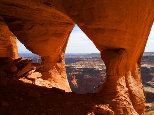
Colonnade Arch (aka Five Hole Arch) in Central Utah definitely fits the description of the “middle of nowhere”. This stunning sandstone formation is located high above the Green River on a side canyon known as Two Mile Canyon. The arch is unique in that it contains five openings, three overlooking the river and two portals in the roof overhead. The fact that it is in the middle of nowhere, Utah means it is rarely visited and you won’t have to fight the crowds or others in your photos such as you would at Double Arch in Arches National Park.
 To get to the arch you will need to drive nearly 100 miles (roughly 45 miles in and 45 miles out) of Utah’s notorious red dirt roads and then hike about one and a quarter mile. Remember this is the middle of nowhere, so there are no signs to the arch along the road, at the trailhead or along the trail. You also need to be forewarned that just to reach the trailhead requires a high clearance vehicle and that the roads become quickly impassable when wet. Oh, one of the few signs you will encounter along the way inform you that a search and rescue extraction could cost between $15,000 and $25,000!
My wife and I visited the site in mid October after a few navigational errors between the trailhead and the arch, arrived unharmed, enjoyed a sack lunch, shot a few hundred pictures and safely drove back to our RV. I highly recommend a visit if you are the adventurous type and properly prepared. Driving miles of infamous roads, crossing uncharted terrain and avoiding thousands of dollars in search and rescue fees, just another adventure in RVing!
If you dare go:
– Let someone know where you are going and when you will return
– Take extra food and water in your vehicle
– Most sane people will start their hike at: N38 34.569 W110 05.407
– If you have the proper vehicle (if not, walk) continue to: N38 34.753 W110 05.254 where you will find a fence designed to stop further vehicle traffic
– Follow the old roadbed northeast until you come to a rock cairn on your right
– Follow the series of cairns and your GPS receiver to N38 35.169 W110 04.598 where you will get your first glimpse of the arch. From there walk about 200ft up and into the arch.
Note: For best lighting plan to arrive at the arch around mid day.
If you are still up for a little adventure, hike the slick rock on the way back to your vehicle and look for the “Dragons Teeth” near N38 34.781 W110 04.918
Click here for more photos of this awesome place.

Leave a Reply